- Support portal
- Evaluation Kits and partner products
u-blox Support
- Product documentation
Documentation
- Investor relations
Investor relations
Technology
|
01 Feb 2024
Achieving centimeter-level positioning requires access to RTK corrections data using an NTRIP service

NTRIP is a protocol for streaming GNSS corrections data over the internet for Real Time Kinematic positioning, commonly referred to as RTK. NTRIP protocol is based on Hypertext Transfer Protocol HTTP/1.1 and is optimized for use with an RTK correction service.
People in the GNSS industry may refer to it as an NTRIP service or even as NTRIP corrections. In reality, NTRIP is a messaging protocol, or the packaging used in the delivery of the corrections data itself.
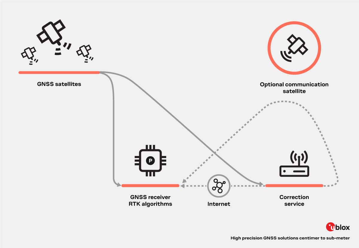
A standard GPS receiver uses the signals from the Global Navigation Satellite Systems to fix a location with meter-level positional accuracy. A high-precision GPS receiver that is also capable of RTK can additionally use RTK corrections data to calculate position with centimeter-level accuracy in real time. ‘In real time’ means at a very fast rate, typically at least once per second.
There are several types of RTK corrections available. What they all have in common is that RTK-based solutions require two-way internet communication between the GNSS receiver device and the GNSS correction service provider. That unicast relationship makes scaling to huge volumes a big challenge.
In contrast, there are more scalable solutions such as Precise Point Positioning (PPP), PPP-RTK, and 3GPP LTE Positioning Protocol (LPP). Since these only require unidirectional communication (IP-based or via satellite L-band), these services can be broadcast to many users over vast regions.
As with the term NTRIP, GNSS industry insiders may lump together the various types of GNSS correction services and call it, ‘RTK’ for short. In plain language, RTK means the ability to know your location, with high accuracy, in real time, and while in motion.
To answer the question, ‘What is NTRIP?’ we need to learn a few more acronyms. Networked Transport of RTCM via Internet Protocol (NTRIP) is a specification standardized by the Radio Technical Commission for Maritime Services (RTCM). RTCM is a governmental body that came up with a way to communicate positions for boats and other vessels many decades ago.
In simple terms, RTCM is a data format commonly used today in the GNSS industry for communicating GNSS corrections data between service providers and users.
NTRIP is a messaging protocol based on HTTP and used for streaming GNSS corrections data over the internet for real time kinematic positioning, commonly referred to as RTK. NTRIP is the messaging format or the ‘packaging’ around the message being sent. RTCM is a standardized data format used to ‘structure’ the message itself. NTRIP protocol is typically used in combination with RTCM. Interestingly, NTRIP can also be used in combination with other optimized data formats such as SPARTN, to stream GNSS corrections.
Our experts are here to answer your questions about u-blox high precision positioning solutions. Contact us for more information.
GNSS correction service

u-blox F9 high precision GNSS module

u-blox F9 high precision dead reckoning module

High precision dead reckoning with integrated IMU sensors

u-blox D9 correction data receiver

u-blox F9 high precision GNSS module

High precision GNSS explorer kit

High precision GNSS explorer kit