

- Support portal
- Evaluation Kits and partner products
u-blox Support
- Product documentation
Documentation
- Investor relations
Investor relations
Technology
|
18 Oct 2023
As satellite IoT connectivity takes shape, it promises to lower the cost and extend the reach of wireless communication to the entire planet, enabling new global use cases and applications.
Space-based infrastructure: LEO, MEO, and GEO satellites
Frequency bands for satellite communication
Transmitting signals back to Earth
The 3GPP initiative for non-terrestrial networks (NTN)
The future of satellite IoT connectivity
Use cases benefiting from satellite IoT connectivity
Satellite IoT communication may well become the next game-changing technology in IoT. The technology has long been looked to as a viable complement to today’s cellular IoT networks, offering a backup solution for cellular connectivity and hardening the resiliency of remote and critical applications. Now, for the first time, new infrastructure, dedicated wireless communication standards, and innovative receiver hardware are promising to bring down the cost of ownership of satellite IoT for non-terrestrial networks (NTN) solutions and grow its reach.
As of today, satellite IoT connectivity outlined in the 3GPP Rel 17 NTN standard is not quite market ready. Constellations still need to be deployed, roaming agreements between cellular and satellite established, and chipsets certified. Still, exciting opportunities exist for solution providers to tap into this bourgeoning infrastructure using proprietary solutions such as the u-blox SARA-S5 multi-mode cellular and satellite module as a steppingstone.
Read on to get up to speed on ongoing developments in satellite IoT connectivity. This page covers the different types of communication satellites, the frequency bands they use to transmit data, the solution architectures outlined in the 3GPP NTN standards, and potential use cases that will benefit from the new opportunities presented by cost-effective, reliable, and, for the first time, truly global IoT connectivity.
Satellite IoT connectivity serves as a complementary solution to terrestrial cellular and non-cellular networks, particularly in remote locations where traditional connectivity may be limited.
Today, only around 10 percent of the Earth's surface has access to terrestrial connectivity services. This leaves a substantial opportunity for satellite-based IoT communications, which are expected to benefit applications in sectors such as agriculture, asset tracking, maritime and intermodal transportation, oil and gas exploration, utilities, construction, and government operations.
The IoT connectivity market has attracted the attention of both established satellite operators and numerous new initiatives, all vying to capitalize on this potential.
With the exponential growth of connected devices leading to unprecedented traffic volumes, the traditional view of satellite and terrestrial networks as separate ecosystems within the telecommunications industry and standardization is gradually diminishing.
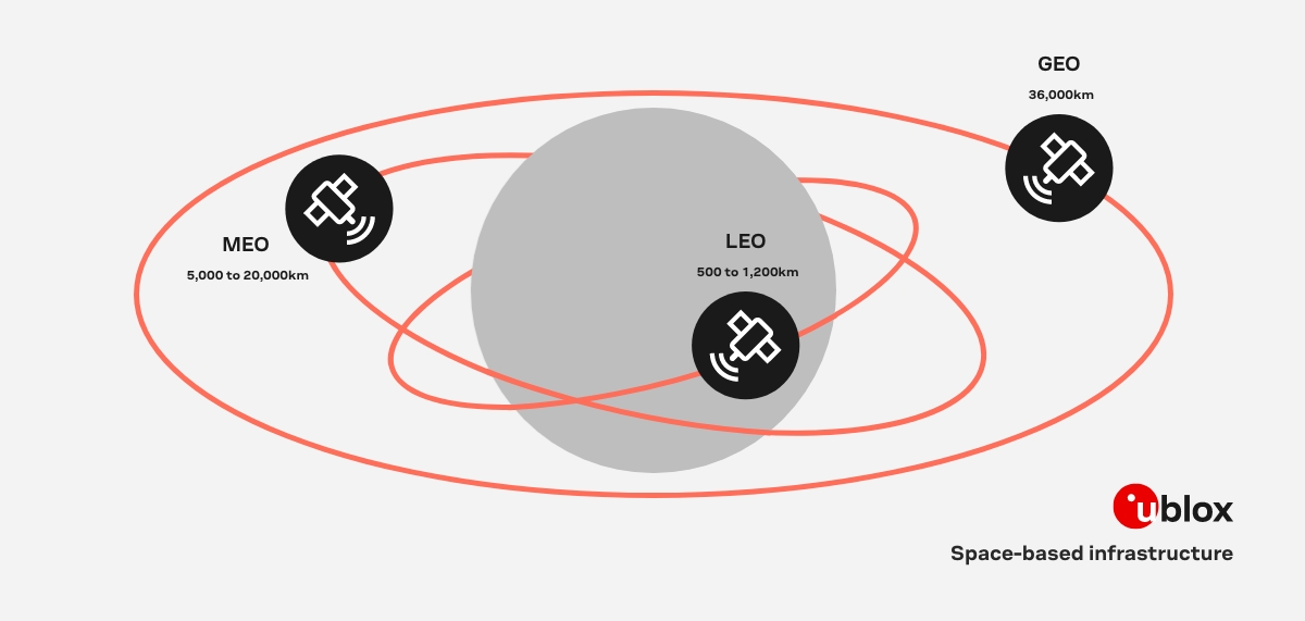
Today’s satellite communication networks utilize different spaceborne platforms, including low Earth orbit (LEO) satellites, medium earth orbit (MEO) satellites, and geosynchronous earth orbit (GEO) satellites.
LEO satellite networks are expected to play a significant role in future integrated networks, offering universal internet and communication services. This explains the resurgence of interest in providing broadband services through LEO satellite mega-constellations, such as OneWeb, Lightspeed, Starlink, and Kuiper.
GEO satellites operate within a geostationary orbit, which is a circular geosynchronous orbit situated 36,000 kilometers above the Earth’s equator. These satellites move in sync with the Earth’s rotation and complete one orbit in 24 hours, traveling at a speed of 11,300 kilometers per hour.
Because GEO satellites remain fixed in the sky relative to any point on the Earth’s surface, ground-based antennas can be permanently directed towards their known position in the sky. To maintain their position, GEO satellites require station-keeping mechanisms.
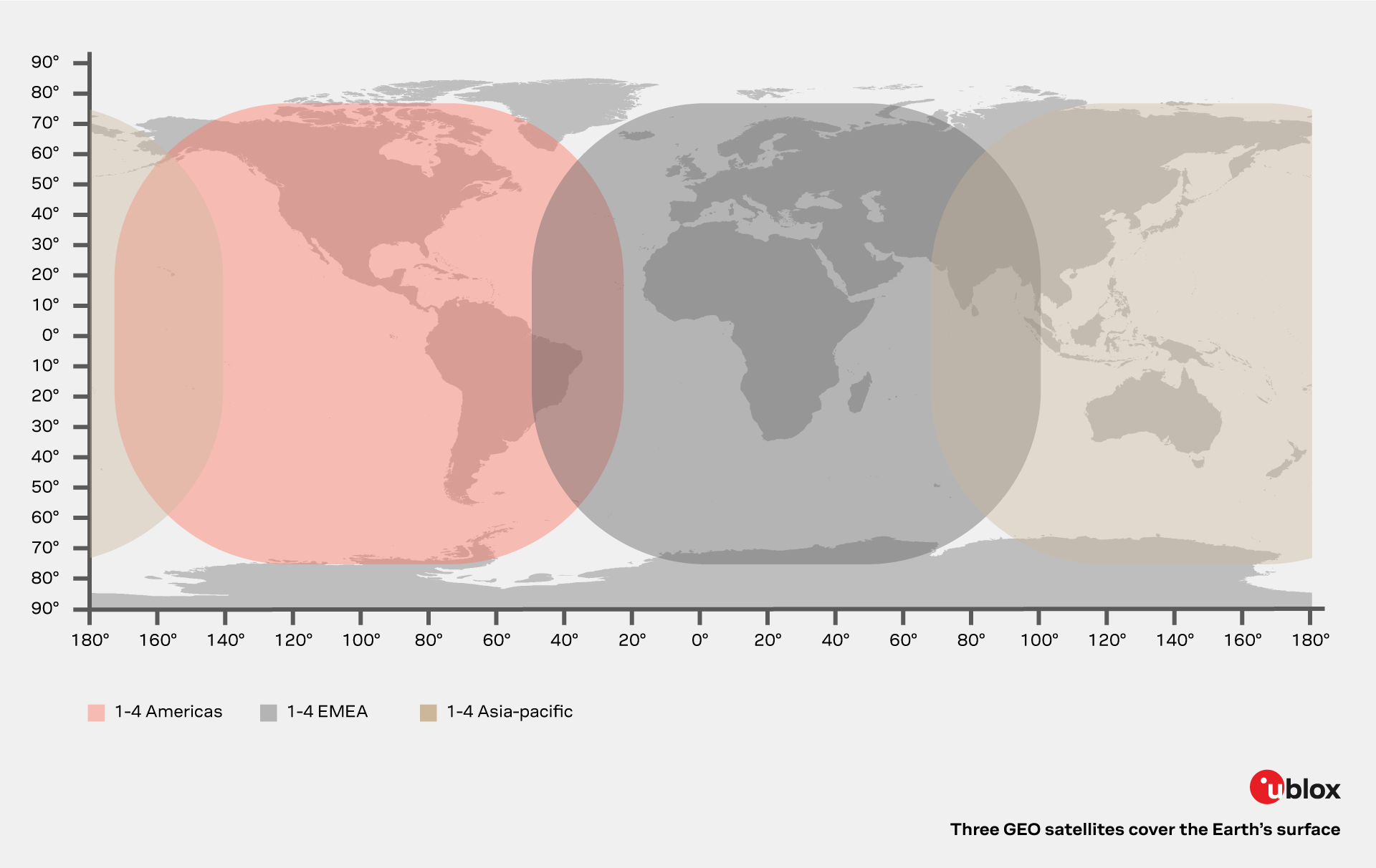
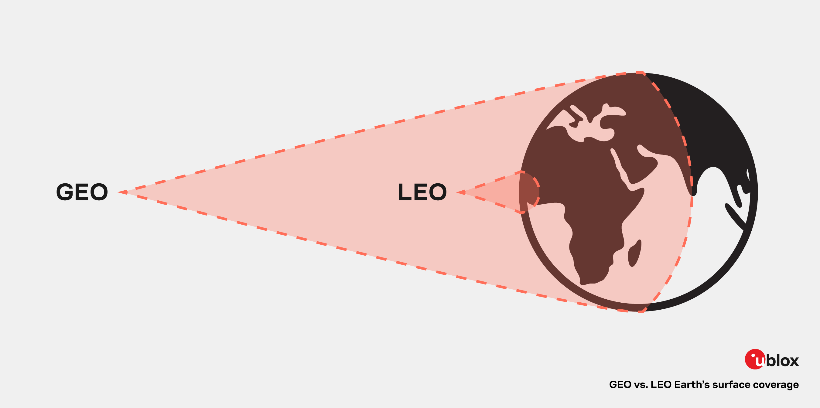
Due to their early entry into the market, most satellite communications are carried out using GEO satellites. Each of these larger satellites can cover up to a third of the Earth's surface, making it possible to cover most of the Earth’s surface with just three satellites.
GEO satellites offer advantages such as no intersatellite handoff and are well-suited for applications like broadcasting, weather forecasting, and satellite radio. They serve as the core infrastructure for global space communications and continue to be developed.
However, as global communication needs evolve and the demand for uninterrupted, low-latency connectivity increases worldwide, limitations caused by the fixed nature of GEO satellites are gaining in importance. For instance, in scenarios where reception is needed in a canyon oriented east to west, a single GEO satellite may be obstructed by a mountain, hindering the provision of service in that area.
LEO satellites operate within a low Earth orbit with a typical orbital period of 128 minutes, resulting in approximately 12 orbits completed per day. The LEO region is generally considered to be below an altitude of 2,000 kilometers. The average orbital velocity required to maintain a stable low Earth orbit is approximately 28,000 kilometers per hour and decreases as the orbital altitude increases.
Due to their lower altitude compared to GEO satellites, LEO satellites have a limited field of view and can only communicate with a fraction of the Earth at any given time. As a result, a network infrastructure is required to provide continuous coverage. This network allows for seamless, uninterrupted communication by utilizing multiple LEO satellites that collectively cover a larger area.
Sufficiently large LEO satellite constellations can offer comprehensive global coverage and deliver low latency, providing an up-to-five-fold improvement over GEO satellites. Theoretically, they can provide users a comparable experience to devices connected through terrestrial fiber connections, with transmit powers in the device that are similar to those of traditional cellular devices.
Latencies measured in the field can depend on the number of LEO satellites in a provider’s constellation, as devices might go hours between overhead passes of a satellite. This can lead to quite large, variable message latencies, as devices may have to wait for a passing satellite to send a message, and the satellite itself may have to wait until it is over a ground station to forward a message.
Moreover, the constant motion of LEO satellites adds complexity in the modem to compensate for timing sync and Doppler frequency shift effects and requires devices to have constantly updated knowledge about when and where a satellite will be visible.
LEO satellite networks are widely used for critical communications, enabling faster connectivity without the limitations of wires or cables. The satellites' continuous motion significantly reduces the likelihood of long or persistent signal blockages, ensuring smoother and more reliable communication, while their overhead position and constant movement eliminate directional obstruction issues.
MEO satellites operate within a wide altitude range that falls between Low Earth Orbit (LEO) and Geostationary Earth Orbit (GEO). Like LEO satellites, MEO satellites can follow various orbital paths around the Earth. Unlike GEO satellites, which must adhere to a fixed path to maintain continuous contact with a ground antenna, MEO satellites are not bound to a specific trajectory.
MEO satellites offer distinct advantages, particularly in terms of navigational applications:
MEO satellites play a vital role in various navigation systems such as the European Galileo System, the Global Positioning System (GPS), and other global navigation satellite systems (GNSS). These satellites enable a variety of positioning applications, from tracking moving aircraft to provide navigation instructions to smartphones.
MEO satellites may not always be the most feasible choice for global communication networks. To establish a robust network for efficient data transmission, MEO satellite constellations often require more than twenty satellites. Due to their diverse orbital paths, maintaining continuous visual contact with stationary ground antennas can pose challenges. Therefore, alternative solutions need to be considered for establishing reliable connections in such scenarios.
It is important to keep in mind several key distinctions between LEO, GEO, and MEO satellites:
| GEO (36,000 km) | MEO (5,000-20,000 km) | LEO (500-1,200 km) | |
|---|---|---|---|
| Altitude latency | High | Low | Very low |
| Earth coverage | Very large | Large | Small |
| Satellites required | Three | Six | Hundreds |
| Data gateways | Few fixed | Regional flexible | Local numerous |
| Orbital speed | Stationary | 1-hour slow tracking | 10-minutes fast tracking |
| Advantages |
High throughput (HTS) technologies enable basic broadband internet applications Fewer satellites over very large fixed geographical areas |
Proven low latency comparable to terrestrial networks, offers fiber-equivalent performance Simple equatorial orbit covers 96% of global population |
Claims support for high-frequency trading, virtual gaming, and high-performance computing applications Smaller, lower power satellites batch-launched more cheaply than GEO |
| Disadvantages |
High altitude and distant ground networking impacts latency-sensitive applications Signal power losses require larger satellites and antennas |
Dual tracking antennas required to maintain continuous connectivity
Inclined plane orbits needed to cover high latitudes |
Very complex tracking and ground network. Complete constellation must be in place before service starts Unproven business model, risky technology, and space debris risk |
Satellite communication generally occurs over one of ten spectrum bands. The specific frequencies available within each band depend on the applicable licensing regulations. While some parts of the bands are globally allocated for satellite use, others may be license-exempt and usable under specific circumstances. The International Telecommunication Union (ITU) is responsible for assigning radio frequencies, including those for satellites. Satellite operators register with their respective local regulatory authorities, such as the FCC in the US and the European Commission in Europe.
Presented below is a compilation of the frequency ranges employed by satellites:
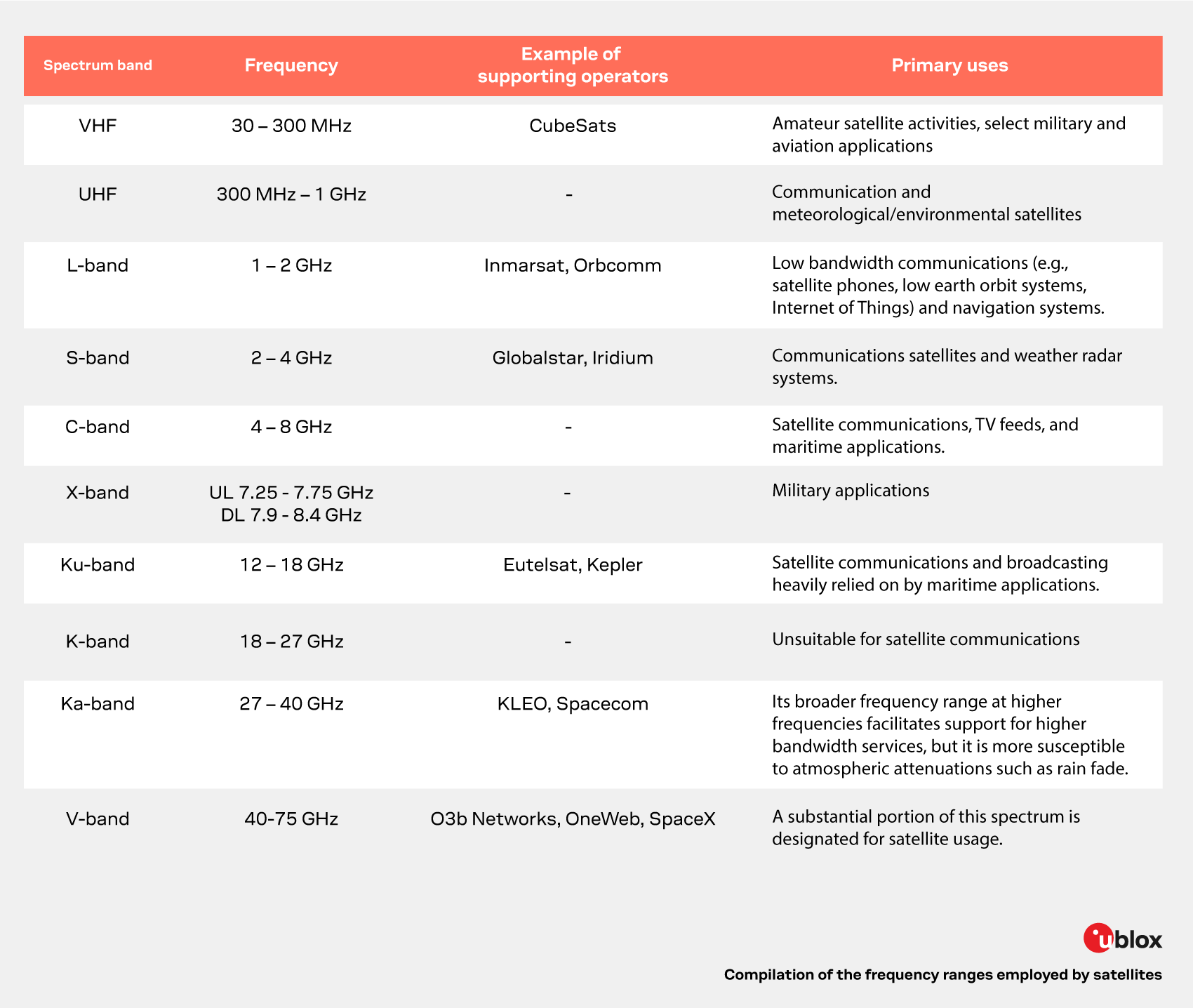
Demand for higher data rates is driving the transition to higher frequency bands. However, higher frequencies entail greater attenuation and lower signal-to-noise ratios (SNR). Consequently, the Ka-band is better-suited for broadband services rather than Internet of Things (IoT) applications. Overcoming the challenges of higher frequencies requires higher power transmission, more expensive steerable and high-gain antennas, as well as directed beams. High-Throughput Satellite (HTS) systems employ beam-forming techniques.
The most common bands for IoT applications, listed in descending order, are L-band, S-band, C-band, and X-band. The higher frequency bands with increased bandwidth capabilities are generally unnecessary for IoT and involve comparatively higher power requirements.
Despite significant differences in the space segment of each network type, their ground infrastructure shares certain similarities. In each case, an IoT device equipped with a satellite antenna transmits IoT sensor data to the satellite and receives control commands from the satellite.
On the ground, a satellite dish serves as a local data sink for any satellite, connecting them to terrestrial networks. These networks delivery the IoT data to an internet data center and, from there, to an endpoint, where users can access and view the IoT data.
Seen from Earth, the various satellite types work similarly, and the choice of the satellite type depends on how its orbital position affects the effectiveness of the solution.
Currently, there are multiple LEO or GEO satellite communication systems that use proprietary satellite IoT communication protocols . These services have been well-established and tested, with a substantial user base that includes millions of subscribers in industries including asset tracking, logistics, transportation, maritime, agriculture, mining, and others.
This stands in sharp contrast with NTN infrastructure, which is still in its nascent stage, transitioning from the definition phase, and has not yet experienced widespread deployments.
The table below summarizes the characteristics of the major incumbent players.
| Operator | Band | Constellation owner | Type | Altitude (km) | Orbit period |
Data |
|---|---|---|---|---|---|---|
| IRIDIUM | L | IRIDIUM | LEO | 780 | 100 m | Voice, data |
| INMARSAT | L | INMARSAT | GEO | 36,000 | 24 h | Voice, data |
| ORBCOMM |
L VHF |
INMARSAT ORBCOMM |
GEO LEO |
36,000 750 |
24 h 100 m | Data |
| GLOBALSTAR | S, L | GLOBALSTAR | LEO | 1,400 | 114 m | Voice, data |
Many proprietary systems have focused on providing satellite phone or messaging capabilities. However, some are specifically well-suited for IoT applications:
IsatData Pro (IDP) is data service offered by ORBCOMM that uses Inmarsat GEO satellites for two-way text and data communications with remote assets. It supports message sizes of 10 kBytes for transmission to mobile devices and 6.4 kBytes from mobile devices, with an average delivery time of 15 seconds. IDP is tailored for mission-critical applications involving fleet management, fishing vessels, oil and gas operations, heavy equipment, remote worker communications, and security applications.
To address the increasing interest in satellite communication, the standards body for cellular communication, 3GPP, has undertaken efforts to adapt 5G New Radio (NR), as well as narrowband IoT (NB-IoT) and LTE for machine-type communications (LTE-M), to offer satellite-based connectivity. They are called NR-NTN and IoT-NTN, respectively. After initially being launched as study items, they have since been enhanced to include normative work.
Since the NTN spec was finalized only in 2022, it will take some time for a full ecosystem to emerge: Satellite providers have a long way to go to before they are prepared for global deployments, which will include assuring landing rights in multiple countries and agreeing on comprehensive roaming agreements with cellular MNOs.
The primary focus of the 3GPP Non-Terrestrial Network (NTN) endeavors thus far has been to provide satellite-based communication services to consumers. The work encompasses supporting various satellite constellations, particularly LEO satellites above an altitude of 600 km and GEO satellites.
Two distinct architectures are available to realize satellite communication systems based on the 3GPP NTN architecture. In general, the satellite radio payload connects to the core network through a satellite ground station or gateway, referred to as the feeder link. The satellite then delivers communication services to user equipment (UE) via the service link.
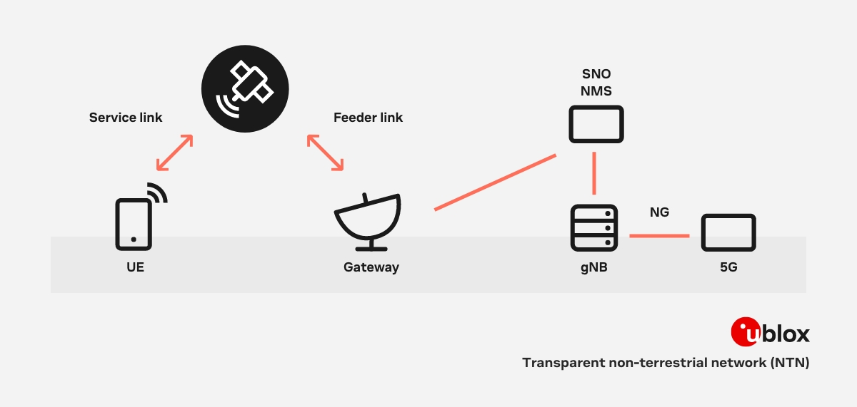
While the image above illustrates the transparent non-terrestrial network (NTN) architecture as specified in 3GPP Rel 17, the algorithms and enhancements are designed to be adaptable to also support the regenerative architecture depicted below.
Transparent architecture: In the transparent architecture, the base station (gNodeB or gNB) is positioned on the ground behind the gateway, with the satellite serving primarily as a repeater. The satellite conducts radio frequency (RF) processing tasks like frequency conversion, amplification, and beam management, without the ability to perform extensive processing functions.
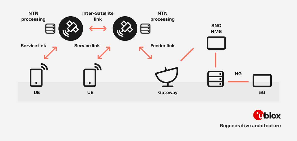
Regenerative architecture: In the regenerative architecture, the satellite contains either a complete gNB or certain components of it, such as the radio unit. This enables the satellite to decode and process packets on board. In this configuration, the feeder link, which connects the satellite to the ground, is like terrestrial fronthaul/backhaul and may not necessarily utilize NR (New Radio) technology. The regenerative architecture offers greater flexibility, improved performance, and global coverage, thanks to its capability to support inter-satellite links.
Modern satellite systems typically divide service areas into numerous sub-areas known as “spot beams,” which are served by individual beams. Each of these areas corresponds to a cell, which can span tens or even hundreds of kilometers in diameter.
When the beams are fixed with respect to the satellite, they sweep across the Earth's surface, resulting in frequent mobility events such as handovers between cells, even for stationary user equipment (UE).
Alternatively, a beam steering mechanism on the satellite may direct the beams towards a specific area on Earth for an extended period. This approach, known as "Earth-fixed beams" reduces the need for frequent handovers by allowing devices to remain within the same beam and cell for several minutes.
While 3GPP Rel 17 supports both alternatives, the concept of Earth-fixed beams offers the advantage of minimizing frequent handovers between cells.
The primary obstacle faced by satellite communication systems is addressing the significant round-trip delays and frequency shifts caused by the satellite's movement in relation to Earth, known as Doppler shifts. Within a single cell, there can also be substantial differential delays of up to 10ms, depending on the size of the cell. Furthermore, the rapid movement of LEO satellites results in substantial Doppler shifts, reaching up to 25 parts per million (ppm), equivalent to 50kHz at a carrier frequency of 2GHz.
The 3GPP solution to address this challenge involves requiring user equipment (UE) to compensate for delay and Doppler shift in the service link before accessing the network. To do so, the UE first needs to download the satellite ephemeris, broadcast by each satellite, which contains information about its position and velocity. The UE can then use its own position, determined using a GNSS receiver, and the satellite ephemeris to calculates its distance to the satellite, its relative velocity, and the pre-compensation values required to account for the frequency shift and timing advance in the satellite signal.
By compensating for round-trip delays and frequency shifts in the UE, the base station (gNB) can operate at its designated frequency and the uplink (UL) and downlink (DL) timing can be aligned, resembling a terrestrial network.
That being said, the long propagation delays in satellite communication necessitate further adjustments. Scheduling timing relationships, originally designed for round-trip times (RTTs) below 1 ms in terrestrial networks, have, therefore, been redefined to accommodate longer delays.
NTNs differ significantly from terrestrial networks in terms of mobility. This is particularly evident in use cases involving LEO constellations, where even stationary user equipment experiences frequent handovers due to the orbital movement of satellites.
Additionally, in terrestrial networks, UEs perceive distinct variations in signal strength based on the distance between the UE and the base station. Conversely, in NTNs, all UEs are located at similar distance from the satellite, resulting in a minor discrepancy in signal strength between the center and edge of a cell. This distinction impacts legacy mobility procedures such as cell selection, which relies on received downlink signal strength.
3GPP Release 17 includes adaptations to NB-IoT and LTE-M that enable them to support non-terrestrial networks (NTNs), collectively called IoT-NTN.
A specific aspect that is unique to IoT-NTN is the concept of discontinuous coverage. Unlike NR-NTN, many use cases in IoT-NTN may not require continuous coverage for UEs. For instance, transmitting data once every few hours may suffice. IoT-NTN opens to door for satellite operators using sparse constellations to support such operations by providing satellite ephemeris for neighboring cells and coverage details, enabling UEs to predict when they will have coverage.
So, what is the relevance of satellite communication for IoT device makers and developers? Satellite is suitable for a broad range of IoT use cases and can serve as a valuable complement to cellular connectivity for applications regularly or even infrequently placed outside of cellular coverage areas. It can also be deployed as a backup solution to cellular connectivity and harden the resiliency of critical applications.
While promising, satellite connectivity following the 3GPP Rel 17 NTN standard is not quite market ready today – constellations need to be deployed, roaming agreements between cellular and satellite need to be established, and chipsets need to be certified. Proprietary solutions, working with incumbent satellite operators, such as the u-blox SARA-S5 multi-mode cellular and satellite module, offer a better path to market into a mature ecosystem.
In the past, multi-mode satellite and cellular connectivity was too expensive to deploy in many cases, but IoT device makers can now benefit in more than one way: Not only has component cost come down, but with the advent of multi-mode modules it is possible to remain connected to lower cost cellular connectivity most of the time and seamlessly switch to satellite when necessary.


