- Support portal
- Evaluation Kits and partner products
u-blox Support
- Product documentation
Documentation
- Investor relations
Investor relations
Tech
|
27 Jun 2023
Astrocast’s new asset tracker connected by u-blox

Over thirty years ago, the advent of satellite positioning technology opened the gates to asset tracking. Satellites, aided by ground infrastructure, have enhanced the positioning horizons from local to national and then to international levels. Parallel to this development, digital communication has undergone a transition, with the Internet of Things (IoT) penetrating various industries, such as transportation, factories, personal devices, homes, buildings, etc., to provide stable and reliable connectivity and communication. During these years, ground networks have been set up and implemented to achieve these IoT connections.
Capitalizing on the development of satellite positioning technology and the progress of the IoT, industries have started producing automotive, agricultural, logistics, and other trackers with accurate positioning capability, reducing their size over time. Yet, these trackers tend to operate only in areas with connectivity infrastructure. It is possible to establish connectivity even where such an infrastructure is absent, although it entails an alternative pathway via a nanosatellite network. A nanosatellite network consists of small and low-cost satellites working alongside the asset tracker to perform remote operations such as monitoring and maintaining assets in the maritime, agriculture, and livestock industries, to mention but a few. This technology, known as satellite IoT, is becoming increasingly available. It is highly advantageous for companies that need secure and reliable IoT satellite communication with assets located in isolated places.
One main challenge for asset-tracking devices that rely on satellite IoT connectivity is power consumption, which mainly depends on the design of devices and how often they need to update their position. Over time, IoT project designers have employed essential design considerations to reduce power consumption to a minimum. As a result, the power demand that constrained IoT applications such as asset tracking need today is a mere fraction of the one required fifteen years ago. But even if devices have been shaped considering various strategies to achieve ultra-low levels of power consumption, when these are in remote places without access to a power supply or regular battery replacement, design considerations might not suffice.
Take an asset-tracking device that can update its position sparingly, for example, a “smart metering” application, which only requires periodic measurements. One would think that, in this case, the power drain isn’t much because the device is not in continuous ‘tracking mode.’ However, a GNSS receiver module that directly obtains information from a satellite consumes much more power compared to one that connects to terrestrial infrastructure. When a smart meter is switched on, it might require tens of seconds or even minutes to compute a position fix, depending on the satellite signal’s strength. This time is enough to consume significant percentages of the battery, an issue far from convenient for assets placed in remote places.
Does this consumption dilemma have any solution? To answer this question, first, we need to review the necessary components for asset tracking through satellite IoT connectivity.
You need roughly three main ingredients to set up satellite IoT connectivity tracking. The first is an LEO (Low Earth Orbit) satellite. LEO satellites orbit low above the surface, between 200 and 2,000 kilometers. To ensure adequate communication coverage and capacity, LEO satellites work in concert with other satellites, a constellation. The second element is a GNSS receiver, which captures positioning information from the satellite constellation. Finally, satellite IoT connectivity trackers must communicate with a cloud location service. Doing so minimizes power consumption, although still providing fair accuracy.
First things first. Let us focus on the GNSS receiver and the cloud location service facilitating satellite IoT connectivity tracking. Today’s GNSS receivers must possess specific characteristics to become good candidates for this enterprise. The three principal ones are a small form factor, ultra-low power consumption, and adaptability to small antennas. The u-blox MAX-M10 is a GNSS receiver fulfilling them all. In terms of size, with its 100mm2, this module enables easy integration when facing space constraints. It also delivers ultra-low power for asset-tracking devices and does not require external components. And even if the size is nano, this does not compromise GNSS positioning performance. Finally, adaptability to small antennas enables this GNSS receiver to operate at the same frequency as other components within the tracker device, considerably impacting the tracker’s size as only one antenna is needed.

And what about the cloud location service? The u-blox CloudLocate service is a comprehensive solution that works with any connectivity technology, including Satellite IoT. CloudLocate enables positioning in the cloud, which is pivotal to extending the energy life of constrained IoT applications.
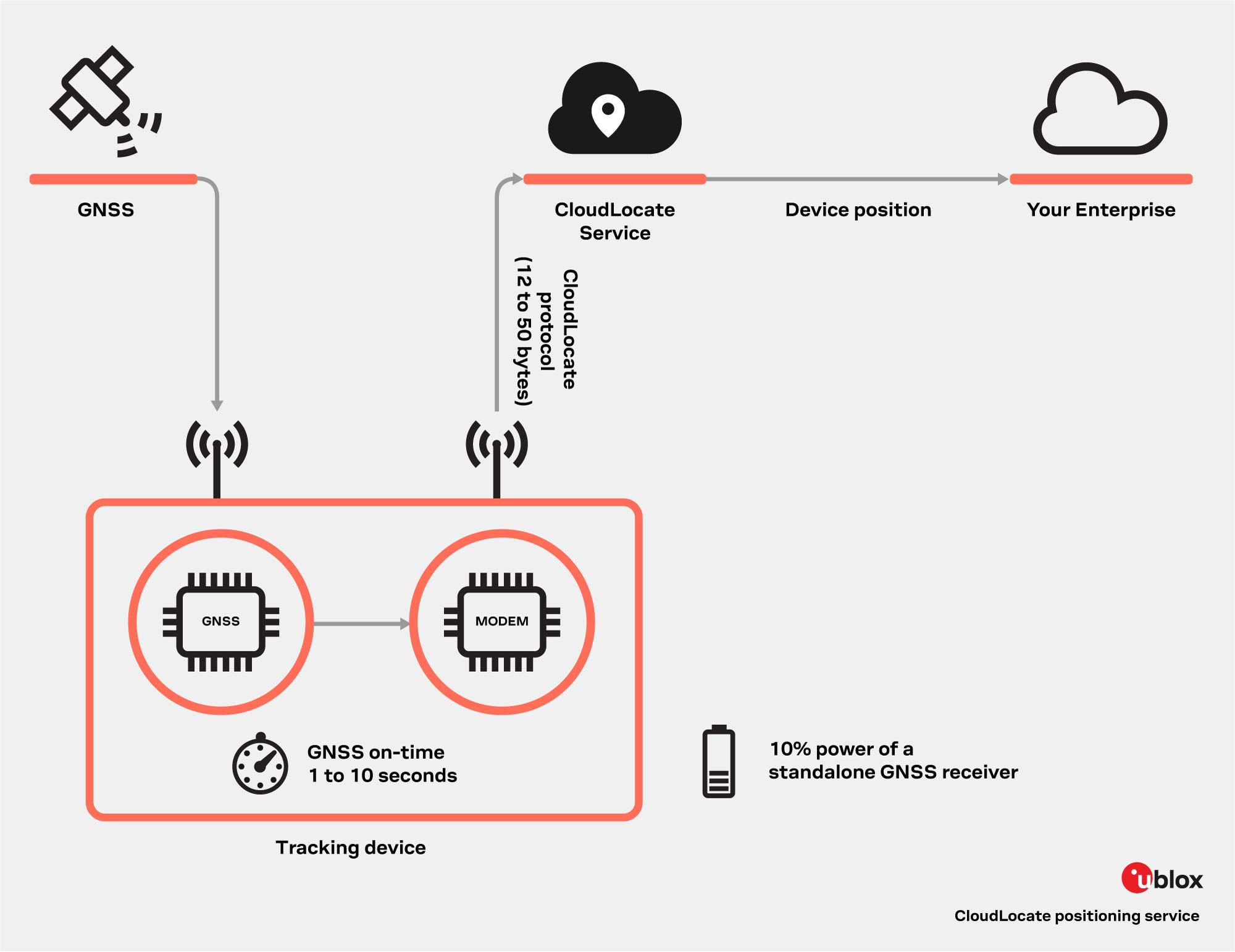
The first main reason CloudLocate is highly convenient is because it acts as an outsourcing entity for data computing. The GNSS receiver itself does not need to calculate the position. On the contrary, these calculations are offloaded to the cloud. Hence, only uplink connectivity is necessary. Although the receiver pre-processes GNSS signals, data is transmitted to the cloud in a packet with a size of between 12 to 50 bytes, where the position calculation takes place. Downlink is not required as CloudLocate delivers the location information to the cloud enterprise where it is used.
CloudLocate has been specifically designed for use cases that only need a few daily updates. It is optimal for devices requiring reasonable accuracy without functioning in a continuous ‘tracking mode,’ for instance, remote trackers. While some assets are in motion, like trucks, and need updates periodically, others might be static and require tracking their position only in specific circumstances, as with livestock.
CloudLocate utilizes only 10% of battery consumption compared to standalone GNSS fix. Since the GNSS receiver does not compute the power-intensive position calculation, a significant reduction in power consumption occurs. This approach saves up to 90% of power consumption compared to the standalone fix, as it ‘turns on’ only for a few seconds to pre-process the GNSS signal and then ‘turns down’ again.

Now let us turn our attention to satellite IoT connectivity. So far, we have described a succinct view of some of the ingredients needed to establish satellite IoT connectivity tracking. Truth is the mechanism is slightly more complex because you also need a satellite communication module to provide features fundamental to connectivity.
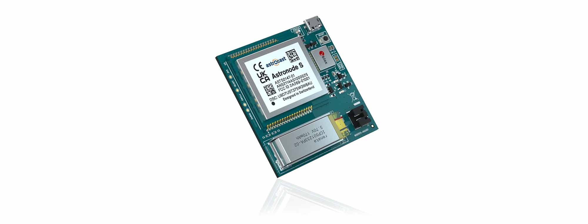
Ideally, this module should ensure bidirectional communication to enable remote change of the tracker’s configuration, e.g., acquisition rates, and transmit on an L-band channel to reduce the number of satellite retransmissions. In addition, data transmission should be secure, through End-to-End encryption, and efficient, to which the L-band already contributes. Finally, the module should withstand temperatures between -20 °C and 70 °C, and the battery voltage should be low, for instance, 3.3 V with peak currents of about 80 mA. You figured it out: we are describing the characteristics of a specific satellite communication module bringing all these features to the game, the Astronode S.
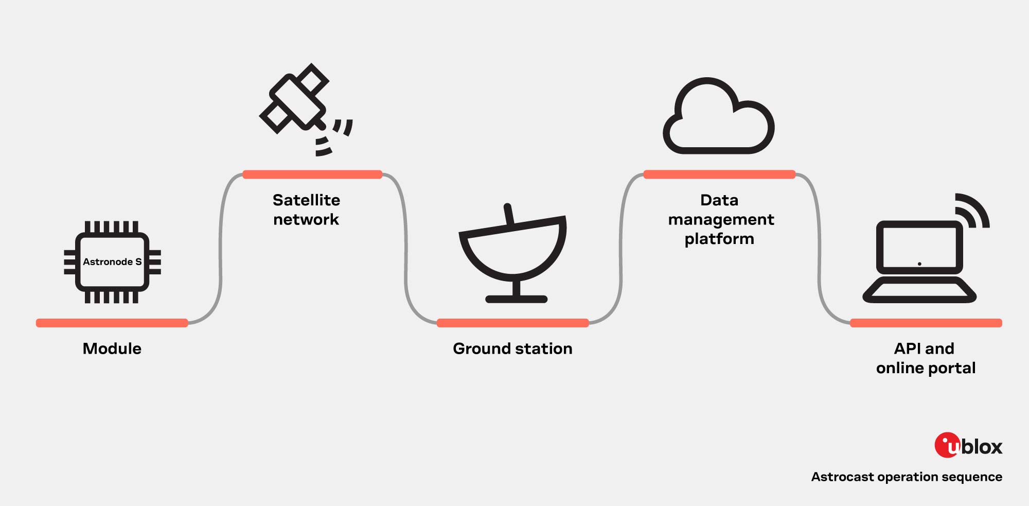
The operation principle of the IoT asset tracker developed by Astrocast is relatively simple. First, the u-blox ultra-low power GNSS receiver MAX-M10 collects data. Then the Astronode S module transmits these data to the Astrocast Satellite Constellation and consequently, to its cloud platform that processes the RAW GNSS samples and sends them to u-blox CloudLocate through an API (Application Programming Interface). The final step involves converting these data into meaningful locations. This process substantially reduces power consumption, saving up to 90% of energy compared to a traditional standalone GNSS fix of 30 seconds after a cold start. With this drastic power consumption reduction, the tracker can operate for months, even when equipped with a small form factor battery.

The synergy between u-blox (M10 + Cloud Locate) and Astrocast results in unprecedented battery efficiency, unlocking access to energy-constrained IoT devices that combine GNSS technology and low-bandwidth - long-range satellite connectivity.
The Astronode S and M10 (L1) operate in the same frequency range, enabling a single antenna to communicate with the Astrocast satellite and listen to the GNSS satellites. Perfect symbiosis and compatibility are reflected in its design, which is compact and lightweight, and also in its convenience as it is a cost-effective solution. But compatibility goes beyond as both u-blox and Astrocast expose APIs to access the data. This enables smooth integration into cloud-based services, resulting in an easy-to-use device.

The satellite IoT connectivity market shows clear growth due to its geographical scope. According to IoT Analytics, the market size will be more than double in 2026, if compared to 2017, reaching about $1 billion. The trend suggests that the solution is rapidly gaining adepts as satellite IoT companies recognize its potential for global coverage, particularly in remote regions with sporadic or absent connectivity. Astrocast has developed a remarkably power-efficient, compact, and reliable asset tracker supported by u-blox components. The GNSS receiver MAX-M10 and CloudLocate have been designed for innovative solutions such as Astrocast’s, which meets all the criteria to impact these new market trends meaningfully.