Technology

|

31 Aug 2021

PPP-RTK GNSS 校正服务 (PointPerfect)

利用 PPP-RTK 克服 GNSS 误差,实现分米甚至厘米级的实时定位。
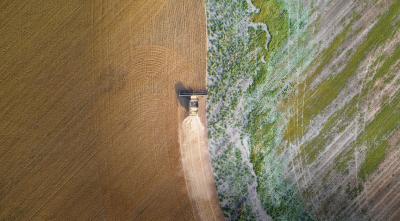
an aerial view of a tractor in a field

全球导航卫星系统(GNSS)已经改变了我们的世界,使任何人都能快速、轻松地确定自己在地球上任何地方的位置。在新型、高度集成的全球导航卫星系统接收器和新一代全球导航卫星系统校正服务的推动下,高精度全球导航卫星系统定位已进入大众市场。

如今,从无人服务机器人到汽车级,汽车应用(如自动驾驶和车道精确导航解决方案),再到工业和消费级无人机,数以百万计的设备都将受益于高精度定位解决方案,这些解决方案可提供低至厘米级的精度。

基于 A-GNSS 的无辅助定位会受到各种误差的影响,从而将可实现的定位精度限制在几米之内。这些误差主要由卫星钟漂移、与预测轨道的轻微偏差或带电离层和对流层产生的信号延迟造成。A-GNSS 校正数据| GNSS 校正服务使用各种技术、传送机制和核心技术来克服这些误差,实现分米甚至厘米级的定位精度。

立即注册*,获得 PointPerfect 30 天免费试用版。

*优惠仅适用于Thingstream新账户。

实时动态定位(RTK)GNSS 校正服务

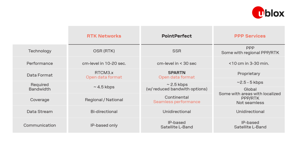
传统的实时动态定位(RTK)GNSS 校正服务通过从一个或多个固定参考站观测卫星信号来确定 GNSS 误差的大小。然后,它们使用基于 IP 的通信将所有观测误差的总和(在距离最近基准站约 30 公里半径范围内保持有效)转场到终端用户。基于 RTK 的解决方案需要在 GNSS 接收机和 GNSS 校正服务提供商之间进行双向通信,并在十至二十秒内达到厘米级的定位精度。

精密单点定位(PPP)GNSS 校正服务

另外,精确点定位(PPP)全球导航卫星系统校正服务广播的全球导航卫星系统误差模型在广阔的地理范围内仍然有效。由于它只需要单向通信(基于 IP 或通过卫星 L 波段),因此可以向任意数量的用户提供服务。传统的 PPP 高精度定位需要三分钟到半小时才能提供精度低于 10 厘米的位置估计,这使其成为测量等静态应用的可行解决方案,但不适合无人机、微移动、精准农业等动态应用。

PPP-RTK:实时授时精度高

近年来,这些用于确定和提供 GNSS 校正数据的既定方法已被整合到 PPP-RTK GNSS 校正服务(有时也称为状态空间表示(SSR)校正服务)中,从而实现了两全其美:将接近 RTK 的精度和快速初始化时间与 PPP 的通播特性相结合。与基于 PPP 的解决方案一样,它们依赖于具有广泛地理有效性的 GNSS 误差模型,并利用单向通信通播不同的 GNSS 误差元器件(或状态)。然后,GNSS 接收机计算其特定位置的 GNSS 校正数据 GNSS 校正。额外的统计信息可进一步支持 GNSS 接收机使用的算法。

PPP-RTK GNSS 校正服务的最终用户优势

End-user benefits of PPP-RTK GNSS correction services

随着高精度 GNSS 解决方案大众市场的出现,对可扩展的高精度定位解决方案的需求也在不断增加。PPP-RTK GNSS 校正服务是一个理想的解决方案,原因有以下几点:

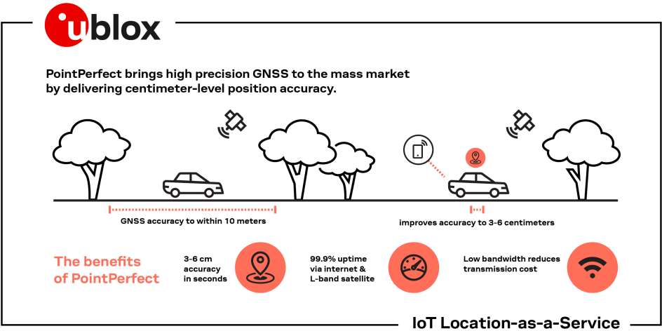
  • 支持 PPP-RTK 的全球导航卫星系统接收器可在数秒内提供厘米级定位。
  • 可向任意数量的 GNSS 接收机通播单个 GNSS 校正数据流。
  • 冗余 IP 和基于卫星的通信提高了服务的可靠性和可用性。
  • 大陆覆盖范围实现了无缝定位体验。

什么是 PointPerfect?

u‑blox PointPerfect PPP-RTK GNSS correction


PointPerfect是 u-blox 先进的 PPP-RTK GNSS 增强数据服务,旨在提供厘米级的定位精度,并在秒级收敛时间内完成定位。PointPerfect 专为满足新兴大众市场应用的需求而设计,这些应用需要实时、可靠、精确的定位与授时,并对带宽要求极低、 并可立即提供统一的大陆覆盖范围。

立即注册*,获得 PointPerfect 30 天免费试用版。

*优惠仅适用于Thingstream新账户。

PointPerfect为多个 GNSS 星座和所有影响 GNSS 信号的大规模环境效应提供经过验证的 GNSS 校正数据| GNSS 校正服务,以提供值得信赖的增强服务。该服务通过我们易于使用的Thingstream物联网服务交货期平台提供,消除了复杂性,使用户能够更有效地参与,从而缩短了上市时间。这种组合降低了采用门槛,支持扩大高精度定位解决方案的规模,即使在以前认为此类解决方案不切实际的细分市场也是如此。

了解更多,请参阅PointPerfect 产品简介

查看评估 F9 和 PointPerfect 的不同方法

u-blox 差分技术

利用 SPARTN 数据格式降低传输成本

现代定位系统要求服务提供商和终端用户之间的通信兼具低带宽、高定位精度、可用性、可靠性和完整性。SPARTN 格式是一种由行业推动的信息传输标准,旨在满足这些要求。SPARTN 是一种演变,它将状态表示法的优势与现代化的通信协议基本原理相结合,从而形成了一种带宽优化的解决方案,为终端用户降低了传输成本。

通过 MQTT 实现高效信息传输

当在单个连接上传输许多消息时,高可靠性、轻量级的 MQTT 协议比 HTTP 更高效。更低的开销和简化的信息传输意味着更少的数据和更低的传输成本。MQTT 协议具有可扩展性:向一百万个设备通播消息和只向一个设备发送消息一样容易。

您现在需要的交付 - NTRIP

你问,我们答。我们很高兴与大家分享这个消息: PointPerfect 现在也可通过 NTRIP 协议使用。NTRIP 为您提供了一种新的选择,让您更轻松地连接和使用 PointPerfect。了解有关 PointPerfect NTRIP 交付的更多信息

让您的业务无障碍

PointPerfect 通过Thingstream物联网服务交付平台交付,该平台是一个基于云的交付平台和企业物联网服务管理接口。经过压力测试和验证,可支持数十亿条信息的交付,直观的接口提供了一个自助服务环境,用户可自主管理物联网车队管理、管理计费、监控事件,并对功能进行完全的 API 控制。

除了传统的订购方式外,我们还提供灵活的服务计划,以满足不同客户、用例|使用场景|应用的需求。Thingstream 实现了无摩擦的业务体验,消除了复杂性,使用户能够更有效地参与并缩短上市时间。两者的结合成为高精度 GNSS 解决方案市场发展的一个拐点。

统一的大陆覆盖范围

PointPerfect可在大陆范围内实现统一覆盖,包括离海岸线长达 12 海里(22 公里)的区域。基准网络正在根据市场需求不断扩大。

99.9% 的可用性保证

PointPerfect 通过移动互联网和卫星 L-band 通信提供冗余服务,正常运行时间可达 99.9%,并提供保修和专家支持。

无缝集成

PointPerfect无缝集成到 u-blox 全面的硅到云解决方案和产品中。其中包括行业领先的高精度多频段 GNSS 接收机模块、通信互联硬件和先进的 GNSS 增强服务。所有技术构建块均在公司内部采购,使我们能够全面控制,而不会因外部依赖性而影响响应速度或影响使用寿命。

由于 PointPerfect 基于开放的 SPARTN 格式,因此其使用并不局限于单一的硬件制造商。这样,客户就可以灵活地选择硬件和服务,优化整体投资回报。

受益于 PointPerfect 的使用案例

Applications

Robotic mowers or service robots create a trajectory line or fixed path for daily inspection and then follow that same precise pattern or route on recurring schedules. The low bandwidth data format offered by PointPerfect reduces transmission costs and power for budget-conscious use cases.

Unmanned vehicles such as drones require precise automated trajectories, quick convergence of location data, and accurate geo-tagging. Assignments such as delivery or dock station landing must be precise, at a specific address, and not ten meters off track from the intended target.

Driving automation is an emerging application requiring ultra-accurate and ultra-reliable location data. Vehicles with advanced driving assistance systems (ADAS) can take advantage of location attributes to take over steering, acceleration, and braking in specific scenarios.

Precision agriculture relies on high accuracy GPS technology to guide tractors, sprayers, and other agricultural vehicles using lightbars or assisted steering to improve pass-to-pass accuracy, minimizing damage to the environment. Combining this with variable rate application of agricultural inputs, farmers can save costs by reducing the volume of seeds planted as well as limit water pollution and protect arable land through the efficient use of pesticides, herbicides, and fertilizer.

​More on GNSS Correction Services

GNSS correction services generally fall into two categories, based either on the observation state representation (OSR) or a state space representation (SSR) of the errors. These groups use different techniques, delivery mechanisms, and core technologies to solve the same problem – the mitigation of key GNSS errors (e.g. clocks, orbits, biases, ionosphere, troposphere) in order to enable high precision GNSS performance.

Observation state representation (OSR)

Observation space representation (OSR) correction services are supplied by the legacy GNSS correction services providers. The term observation is used as the core techniques are centered on transferring corrected GNSS observations from the nearest reference station to the rover.

OSR services typically use a standardized format in RTCM v 3.x over IP and the offerings are mainly B2C models focusing on a single geographic region (i.e., a country or state) targeting existing low-volume, niche high precision markets (such as surveying, agriculture, machine control).

While OSR services deliver centimeter-level accuracy provided the rover is within approximately 30 kilometers of the nearest reference station, they require two-way communication with a higher bandwidth, making them difficult to scale up to serve mass market applications.

Schematics-of-Observation-state-representation


Benefits:Downsides:
  • Centimeter-level accuracy
  • Local / regional coverage
  • Established standard format
  • Two-way communication
 
  • Higher bandwidth need
 
  • Correction data tailored to each location or vicinity

State space representation (SSR)

State space representation (SSR) correction services are the latest generation of GNSS correction services provided by new entrants and the larger legacy providers. The term state is used as the core techniques are centered on using the reference station network to model the key errors over large geographical regions and transferring them to the rover. The rover uses the incoming data to create a local model of the GNSS errors, which it applies directly to the GNSS observations. The performance of SSR correction services depends on which errors are transmitted to the rover device, as detailed in the table below.


Service TypeSat.clocks & orbitsGlobal IonoBiasesRegional Iono / TropoCoveragePerformance
SBAS

Regional  Continent

meter in sec

PPP

□*

  Global

meter in sec

PPP-AR

 Global

decimeter in min

PPP-RTK

Continent

centimeters in sec


Furthermore, the broadcast nature of SSR corrections enables the service to be more easily distributed over IP and even L-Band satellite communication channels. In addition, providers of SSR services are focusing on scalable B2B models to meet the demands of high precision mass market applications such as in the automotive field.

SSR services achieve centimeter-level positioning accuracies over large geographic areas requiring low bandwidth. Because all roving GNSS receivers rely on the same GNSS correction data stream, SSR services are a good fit for mass market applications.

infographic presenting state space representation known as SSR


Benefits:Downsides:
  • Centimeter-level accuracy 
  • Often proprietary formats
  • Global coverage
 
  • One-way communication
 
  • Lower bandwidth need
 
  • Performance levels differentiation


To learn more, see:

Discover more