

- Support portal
- Evaluation Kits and partner products
u-blox Support
- Product documentation
Documentation
- Investor relations
Investor relations
Technology
|
01 Mar 2024
Cm-level accuracy powered by deep expertise in GNSS and RTK technology.
The market for scalable, high precision positioning technology is proliferating. The automotive world, with next-generation ADAS and V2X applications, and robotics, with applications such as UAVs and robotic lawnmowers, require appropriate high precision solutions to meet specific needs.
As these sectors demand customized high precision solutions, u-blox considers complexity, size, power, and cost constraints to provide the most ad hoc solutions for current and future needs.
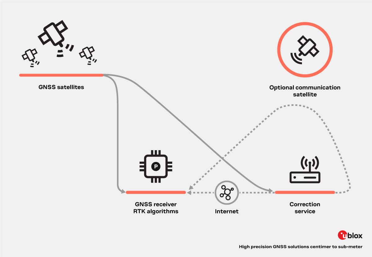
High precision positioning results from combining Global Navigation Satellite Systems (GNSS), such as GPS, Galileo, and BeiDou, with Real-Time Kinematic (RTK) technology. High precision GNSS solutions consist of several key components:
High precision GNSS antennas. The GNSS antenna is critical to achieving GNSS accuracy. Factors such as the operating GNSS signal level (approx. -130 to -167 dBm), radiation pattern, gain, polarization, and an impedance to match with the transmitter or receiver system (ideally 50 Ω at GNSS frequencies) determine the scope of the antenna. For more information on GNSS antennas, read our use case.
RTK. A technique that uses the receiver’s measurements of the phase of the satellite signal’s carrier wave. These measurements, combined with corrections from a local or virtual base station, allow the receiver to resolve carrier ambiguities and provide centimeter-level accurate position information to the end user, typically a moving device called a rover.
Correction services. High-quality GNSS corrections can significantly improve the accuracy and integrity of GNSS. These data streams, transmitted wirelessly to the rover, contain real-time information about GNSS signal errors to GNSS receivers, enhancing their performance precision and enabling positioning accuracies to the centimeter and below.
In addition to the high precision positioning components mentioned above, dead reckoning is a value-added feature that also plays a relevant role in achieving reliable performance, especially in urban environments.
High precision solutions deliver centimeter to sub-meter GNSS accuracy in seconds to minutes, depending on component selection, configuration options, and correction data inputs.
There are different types of high precision solutions based on the correction data input they rely on:
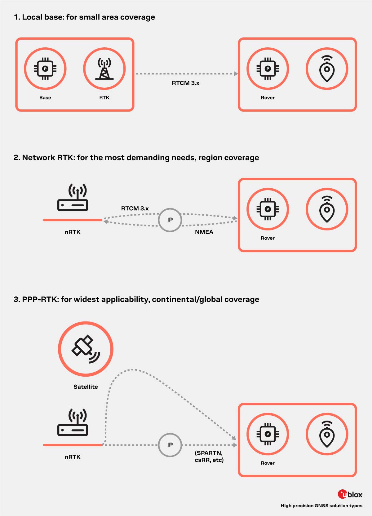
Our advanced GNSS modules, characterized by high integration and precision, are the core of the high-precision GNSS solution. The combination of satellite signal receivers with embedded RTK algorithms, various value-added features, and open interfaces enables easy and efficient integration with communication and correction services based on the following:
In addition, open, industry-standard hardware and software interfaces provide unmatched ease of use and flexibility. These contribute to the implementation of various types of navigation solutions for GNSS accuracy.
A device with an integrated u-blox high precision GNSS receiver module can be flexibly reconfigured to operate in the desired solution type, depending on the correction data or service available.
By implementing module firmware upgrade functionality on the device, system integrators can enable GNSS module upgrades and feature enhancements even for devices in the field.
Building on the success of our NEO-M8P series of high precision GNSS modules and drawing on our extensive experience in GNSS positioning technologies, including dead reckoning, multi-band, RTK, and GNSS correction services, we have developed the u-blox F9 platform. The platform delivers the next level of scalable GNSS high precision technology, paving the way for new navigation applications such as unmanned vehicle navigation, automated driving, and various machine automation applications.

To learn more, see:
Vehicles with different levels of autonomy must determine their position relative to their surroundings within centimeters. This is critical for optimal maneuvering in different situations.
The accuracy of positioning functions relies on multiple inputs, including cameras, radars, HD-MAPs, IMU, GNSS, and other technologies. GNSS stands out as the sole technology offering absolute positioning down to centimeters. This feature makes it an indispensable tool for Advanced Driver Assistance Systems (ADAS).
By using GNSS absolute positioning, vehicles can decide whether to activate specific ADAS functions without compromising passenger safety. GNSS is an effective complementary sensor in the localization process due to its robustness to environmental disturbances. This capability becomes particularly valuable in meeting safety objectives for deploying highly automated driving solutions that must comply with standards such as:
From our family of high precision positioning products, the A9 functional safe GNSS chip, tailored for ADAS applications up to 105 °C, enables lane identification.
To learn more, see:
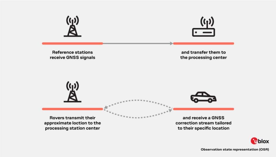
GNSS correction services generally fall into two categories, based either on the observation state representation (OSR) or a state space representation (SSR) of the errors. These groups use different techniques, delivery mechanisms, and core technologies to solve the same problem – the mitigation of key GNSS errors (e.g. clocks, orbits, biases, ionosphere, troposphere) in order to enable high precision GNSS performance.
Observation space representation (OSR) correction services are supplied by the legacy GNSS correction services providers. The term observation is used as the core techniques are centered on transferring corrected GNSS observations from the nearest reference station to the rover.
OSR services typically use a standardized format in RTCM v 3.x over IP and the offerings are mainly B2C models focusing on a single geographic region (i.e., a country or state) targeting existing low-volume, niche high precision markets (such as surveying, agriculture, machine control).
While OSR services deliver centimeter-level accuracy provided the rover is within approximately 30 kilometers of the nearest reference station, they require two-way communication with a higher bandwidth, making them difficult to scale up to serve mass market applications.
| Benefits: | Downsides: |
|---|---|
|
|
|
|
| |
|
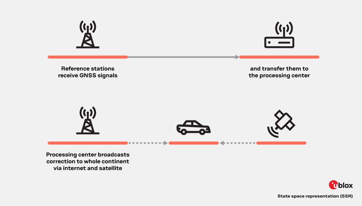
State space representation (SSR) correction services are the latest generation of GNSS correction services provided by new entrants and the larger legacy providers. The term state is used as the core techniques are centered on using the reference station network to model the key errors over large geographical regions and transferring them to the rover. The rover uses the incoming data to create a local model of the GNSS errors, which it applies directly to the GNSS observations. The performance of SSR correction services depends on which errors are transmitted to the rover device, as detailed in the table below.
| Service Type | Sat.clocks & orbits | Global Iono | Biases | Regional Iono / Tropo | Coverage | Performance |
|---|---|---|---|---|---|---|
| SBAS |
█ | Regional | Continent |
meter in sec | ||
| PPP |
█ |
□* | Global |
meter in sec | ||
| PPP-AR |
█ |
█ | █ | Global |
decimeter in min | |
| PPP-RTK |
█ |
█ | █ | █ | Continent |
centimeters in sec |
Furthermore, the broadcast nature of SSR corrections enables the service to be more easily distributed over IP and even L-Band satellite communication channels. In addition, providers of SSR services are focusing on scalable B2B models to meet the demands of high precision mass market applications such as in the automotive field.
SSR services achieve centimeter-level positioning accuracies over large geographic areas requiring low bandwidth. Because all roving GNSS receivers rely on the same GNSS correction data stream, SSR services are a good fit for mass market applications.
| Benefits: | Downsides: |
|
|
| |
| |
| |
|
To learn more, see:

High precision GNSS explorer kit

High precision GNSS explorer kit

u-blox F9 high precision GNSS module

u-blox F9 high accuracy timing module

u-blox F9 high precision dead reckoning module

u-blox F9 high precision GNSS module

u-blox D9 correction data receiver

u-blox QZSS L6 correction data receiver

u-blox M8 high precision GNSS modules

High precision dead reckoning with integrated IMU sensors

u-blox A9 functional safe GNSS chip